)
Snow this afternoon, rain and snow tonight, cloudy tomorrow, sunny on Sunday. Today, there will be snow with a high near 34 and a west wind around 16 mph. Tomorrow, it will be cloudy with a high near 45 and a west northwest wind. More details...
Central Indiana: Snow and wind tonight, up to 2 inches possible. No hazardous weather expected after tonight. The National Weather Service provides forecasts, past weather data, safety information, and educational resources to the public. The Hazardous Weather Outlook for central Indiana warns of snow and wind gusts, with up to 1-2 inches of snow possible. Spotters are encouraged to report any observed snowfall amounts or travel impacts. No hazardous weather is expected in the coming days. More details...
Social Media Helper: Get ready for a snowy afternoon in Bloomington, IN with less than an inch of accumulation possible. But don't worry, the weekend is looking brighter with sunny skies and temperatures in the 50s! #weatherforecast #sunshineahead ☀️🌨️ https://forecast.weather.gov/MapClick.php?lat=39.1660&lon=-86.5125&unit=0&lg=english&FcstType=text&TextType=1

Heavy rain and flooding in California, windy in Pacific Northwest, snow in Northeast, tranquil in central and southern U.S. The Weather Prediction Center in College Park, MD, is forecasting a strong atmospheric river bringing heavy rain and flooding to northern California through Friday. A developing storm system will bring gusty winds to the Pacific Northwest and heavy mountain snow to the northern Rockies. Unsettled weather is expected in the Northeast and Great Lakes, with heavy snow in the central Appalachians and higher elevations of Pennsylvania and New York. The central and southern U.S. will experience tranquil conditions, while below-average temperatures are forecast from the Mississippi Valley to the Southeast. Freeze warnings are in effect for the Deep South. More details...
Upcoming Threats: US Hazards Outlook: Nov 24-28, 2024 The U.S. Hazards Outlook for days 3-7 is provided by the Weather Prediction Center of the National Oceanic and Atmospheric Administration. The outlook includes information on precipitation, temperature, wildfires, and soils from November 24-28, 2024. The outlook is updated twice daily during the week and caution is advised when using it over the weekend. Additional resources and information on hazards affecting different regions of the U.S. are also available on the website. More details...
Today: No severe thunderstorms expected tonight. The Storm Prediction Center's Day 1 Convective Outlook for November 21, 2024, indicates that severe thunderstorms are not expected for the day. A line of convective rain and snow showers is present across the Appalachians with occasional lightning flashes, but this is expected to weaken as the day progresses. Lightning is expected to remain offshore near the New England and Pacific Northwest coasts. Overall, isolated thunderstorms are possible in certain areas, but severe weather is not anticipated. More details...
Tomorrow: Pacific Northwest Coast: Few storms, no severe. The Storm Prediction Center's Day 2 Convective Outlook for November 21, 2024, indicates that a few thunderstorms are possible along the Pacific Northwest Coast, but severe storms are not expected. The outlook discusses the weather patterns across the CONUS, with a deep upper low off the East Coast and a trough off the West Coast. Cool and stable offshore flow is expected over the eastern 2/3rds of the CONUS, limiting buoyancy and deep convection. In the Pacific Northwest, scattered low-topped convection is likely with weak MUCAPE, potentially leading to sporadic lightning and strong wind gusts near the coast. More details...


Today: High risk of excessive rainfall in northwest California. The Weather Prediction Center (WPC) has issued a high risk for excessive rainfall across portions of northwest California and southwest Oregon. The forecast discussion highlights the potential for life-threatening flooding due to a strong atmospheric river impacting the region. The forecast includes heavy rainfall, with expected storm totals of 12-16 inches in some areas. The WPC warns of significant flood risks, debris flows, and burn scar flash flooding concerns. The forecast period is from 16 UTC Nov 21, 2024, to 12 UTC Nov 22, 2024. More details...
Tomorrow: Day 2: Moderate risk of excessive rainfall in Northern California. The WPC Day 2 Excessive Rainfall Outlook predicts a moderate risk for excessive rainfall across portions of Northern California. A new surface low is expected to deepen near the Oregon coast, bringing heavy rain and the potential for flooding. Antecedent rainfall combined with rain rates of 0.5 to near 1 inch per hour could lead to numerous flooding concerns, especially in burn scar locations. The forecast also includes widespread rainfall over coastal areas and the Sierra Nevada, with a continued flood threat and risk of landslides. More details...


Today: Elevated fire weather in Southeast and Florida. The Storm Prediction Center's Day 1 Fire Weather Forecast for November 21, 2024, shows no risk areas forecasted. The previous forecast remains unchanged, with winds increasing to around 15 mph and relative humidity falling into the 30-40% range. A period of elevated fire weather is expected in North Florida due to dry fuels and strong winds behind a cold front. Winds of 10-15 mph and RH near 20% are expected, with gusts up to 20 mph possible. More details...
Tomorrow: Elevated fire risk in central FL tomorrow. The Storm Prediction Center's Day 2 Fire Weather Forecast for November 21, 2024, indicates no critical fire risk areas, but an elevated risk area has been introduced for portions of central Florida. Dry and windy conditions, along with limited rainfall, may lead to a fire concern in the region. The forecast for Friday shows minimal fire weather conditions for most areas, with northern and central Florida expected to be dry with slightly cooler temperatures and higher relative humidity. Overall, fire weather conditions are expected to be less severe compared to Thursday. More details...


Increased precipitation leads to widespread improvement in drought conditions across the United States. The Drought Monitor report for the week of November 21st shows continued improvement in dryness and drought conditions across the Contiguous 48 states, with heavy precipitation in several regions leading to sizeable areas of improvement. However, the Northeast continues to experience record low precipitation amounts, leading to deteriorating conditions. Over the next five days, moderate to heavy precipitation is expected in the western and northeastern quarters of the contiguous states, while the Plains and southern tier may see lesser amounts. The Climate Prediction Center's outlook for November 26-30 favors above-normal precipitation in several regions, while the southern tier of the country is expected to be warmer than normal. Puerto Rico remains free of dryness or drought, while the U.S. Virgin Islands saw heavy rain leading to improved conditions. The South and Southeast Regions experienced variable rainfall, with some areas seeing significant improvement while others continued to experience dryness and deterioration. More details...
Real-time power outage tracking across the United States. In Washington, there are currently 291,410 customers without power. California has 17,327 customers experiencing power outages, while Georgia has 14,072 customers affected. Alabama follows with 7,806 customers without power, and the Virgin Islands have 6,676 customers experiencing outages. These numbers are constantly being updated every ten minutes on PowerOutage.us to provide the most accurate information on power outages across the United States. More details...
Recent N America earthquakes: 14 >4.0 magnitude, uniform distribution Recent earthquakes in the North America region have been recorded, with 14 earthquakes of magnitude greater than 4.0 reported for uniform distribution. The earthquakes occurred in various locations such as Nevada, Northern Yukon Territory in Canada, Western Texas, and off the coast of Oregon and California. There are concerns about a missing quake and wrong magnitude reported, prompting further investigation by sources. More details...

About this section: Space weather is a periodic threat to radio communications, and in extreme cases satellites and the power grid. To learn more about space weather, we recommend Spaceweather.gov or the FEMA IS-0066 course
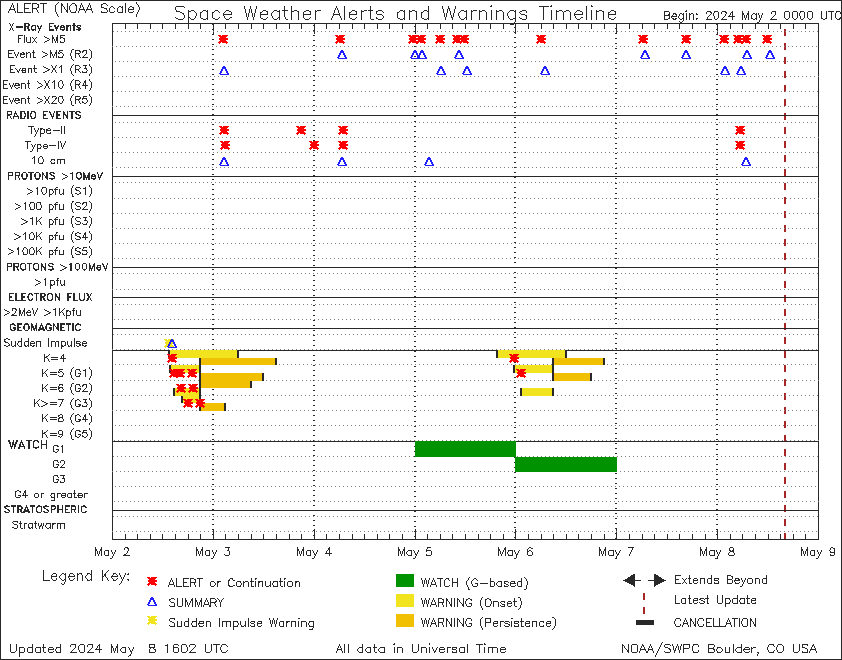
Solar activity is expected to be low with a chance for M-class flares, while the geomagnetic field is expected to be mostly quiet with a chance for isolated active periods. Solar activity was moderate with flares from Region 3897 and Region 3898. Region 3901 added low-level flares, while Region 3902 was newly numbered. No Earth-directed CMEs were observed. Solar activity is expected to be low with a chance for M-class flares and a slight chance of X-class events. Energetic particle flux levels are expected to remain normal to moderate. Solar wind parameters showed a weakly enhanced regime before transitioning to background levels. Geomagnetic field was quiet to unsettled and is expected to remain mostly quiet with a chance for isolated active periods due to CH HSS influences. More details...
This is a beta-test product and should not be used as the sole basis for decision-making. Be sure to double-check all facts before using the social media helper. Please let us know how we can improve the briefing at konnex.ai/feedback. If you no longer wish to receive the briefing, unsubscribe at konnex.ai/unsubscribe.
Click here to view our Privacy Statement.